

Western Lake St. Joseph Iron Project
Rockex has a 100% direct interest in the Western Lake St. Joseph Iron Project, consisting of 216 contiguous mining cell claims covering a nominal area of approximately 4,428 hectares located approximately 100 kilometres northeast of Sioux Lookout and 80 kilometres south-southwest of Pickle Lake.
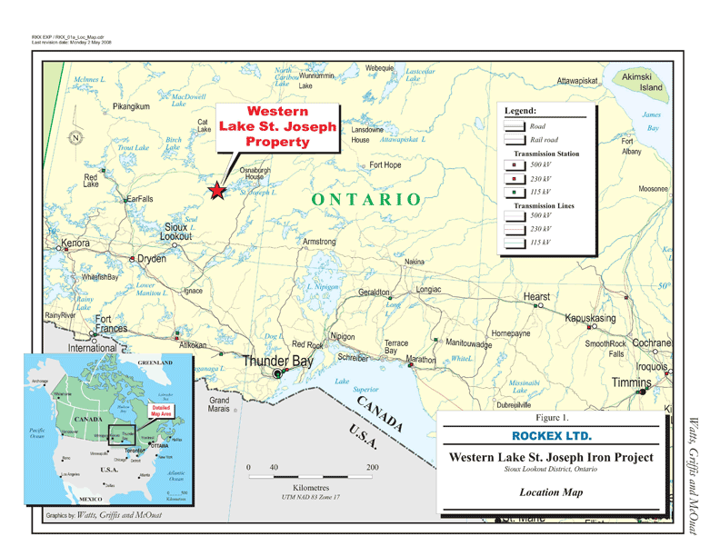
In February 2011, Rockex received a technical report providing a Mineral Resources Estimate for its Eagle Island Deposit in its 100%-owned Western Lake St. Joseph Iron Ore Project. That report has been superseded by the updated resource estimate included within the PEA which was filed on Sedar on October 11, 2013 and described above.
Exploration Activities
In October 2011, a drilling program started at the Eagle Island Deposit with a view to upgrading the classification of various parts from Inferred Resources to Measured and Indicated Resources and adding to the estimated size of the deposit. The program was designed to test the anomalies identified in the Corporation’s recent airborne survey, and the mineralized zone at Eagle Island at depths below 300 metres, as well as the mineralized zone at Fish Island. A drill arrived on site in early October with a second drill having arrived later in the same month. On November 30, 2011, the Corporation announced the first set of assay results from its drill program in its Western Lake St. Joseph Project. Drill hole EI-106 intersected 524.3 metres of mineralization with an average grade of 29.93% total iron. The intercept extended known mineralization at Eagle Island to an estimated vertical depth of 564 metres, nearly 200 metres below the deposits outlined resources. The true width of the mineralized zone at depth was estimated to be 495 metres.
On February 2, 2012, the Corporation announced additional results of its drill program at its Western Lake St. Joseph Project. Drill hole EI-110 in the Southwest Extension at Fish Island (3 km west of the Main Zone at Eagle Island) intersected 470.6 metres (248 metres estimated true width) with an average grade of 29.2% total iron, including 132 metres (69 metres estimated true width) grading 37.02% total iron and 234.5 metres (130 metres estimated true width) grading 33.82% total iron. The first drill hole by Rockex in the Southwestern Extension at Fish Island indicated that the iron mineralization reaches a vertical depth of 390 metres. Historical records prepared by Pierre Mauffette in 1956-57 and by A.E. Boerner in 1957 and by Hanna Mining and Algoma Steel in 1975 show the Fish Island Deposit was tested only to a depth of 180 metres and was estimated to hold 258 million tons with a grade of 33% soluble iron. (This historical estimate pre-dated NI 43-101 and, accordingly, is not compliant with the requirements of NI 43-101. No qualified person has done sufficient work to classify the historical estimate as current mineral resources or reserves. As a result, the historical estimate cannot be relied upon. Rockex is not treating the historical estimate as current mineral resources or mineral reserves.) The Company also announced three additional holes in the Southeast Extension at Eagle Island, the best of which was 337 metres of 27.7% total iron (262 metres estimated true width).
On April 17, 2012, the Corporation announced new assay results from seven drill holes completed in its drill program at its Western Lake St. Joseph Project. Drill hole EI-112 tested the Southwest Extension at Fish Island and intercepted 33.43% total iron over 375 metres (estimated true width: 251 metres). This mineralization included two well-defined horizons that intercepted respectively 35.85% total iron over 204 metres (estimated true width: 131 m) and 33.32% total iron over 153 metres (estimated true width: 106 m). This second drill hole by Rockex in the Southwest Extension was drilled facing the previously-reported EI-110 diamond-drill hole and the grades reported are comparable to the ones reported in the February 2012 announcement described above.
From east to west, drill holes EI-115, EI-111, EI-117, EI-113 and EI-114 targeted the southern portion of the Main Zone over a strike length of 850 metres. Drill hole EI-115 intersected the Main Zone between 338 and 752 metres for an average grade of 22.24 % total iron over 441 metres (estimated true width: 381 m). That intersection ends 180 metres below the currently defined resources. The top portion of the hole was collared on the southern side of the bay which hosts a north-dipping iron formation; assays of 21.74 % total iron over 51.3 metres are to be considered down-dip values. Drill holes EI-111 and EI-117 are on the same section. The deeper drill hole EI-111 returned 23.99% total iron over 402 metres (estimated true width: 312 m). A first iron formation assayed 27.27 % total iron over 195 metres (estimated true width: 142 m). A second higher grade iron formation reported 30.00 % total iron over 120 metres (estimated true width: 100 m). The deepest intersection on holes EI-111 tested the iron formation 185 metres below the current resources. Drill hole EI-117, located 150 metres above EI-111 returned 25.40 % total iron over 330 metres (estimated true width: 266 m). Drill hole EI-113 intersected 210 metres (estimated true width: 185 m) of iron grading 24.56 % total iron, 100 metres below currently defined resources, whereas diamond drill hole EI-114 intersected two distinct iron formations grading, respectively, 26.72% over 189 metres (estimated true width: 153 m) and 26.42 % total iron over 24 metres (estimated true width: 21 m) on the western side of the Main Zone. The larger intersection met the iron formation 78 metres below existing resources whereas the smaller formation was never encountered in historical drilling work.
On the southeastern part of Eagle Island, the iron formation extends to form the north and south limbs of a fold. Diamond drill hole EI-116 reported in the April 17, 2012 news release was designed to intercept known iron mineralization on the Southeast Zone’s south limb as well as to test the magnetic anomaly highlighted in the airborne magnetometric survey undertaken in the summer of 2011 that is sitting in the channel between Eagle Island and the mainland. The first intersection returned 27.55 % total iron over 66 metres (estimated true width: 55 metres) for the Southeast Zone. The magnetometric anomaly was successfully encountered at depth and returned values of 19.53 % total iron over 87 metres (estimated true width: 87 m).


